Back جبل تيريڤاكا ARZ Terevaka Catalan Cerro Terevaka CEB Maunga Terevaka Czech Maunga Terevaka German Maʻunga Terevaka Esperanto Ma'unga Terevaka Spanish Maunga Terevaka French מאונגה טרוואקה HE ტერევაკა Georgian
| Ma'unga Terevaka | |
|---|---|
 | |
| Highest point | |
| Elevation | 1,664 ft (507 m)[1] |
| Coordinates | 27°5′4″S 109°22′46″W / 27.08444°S 109.37944°W |
| Geography | |
 | |
| Location | Easter Island |
| Geology | |
| Mountain type | Shield volcano |
| Last eruption | Pleistocene, less than 110,000 years ago |
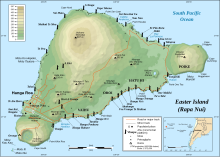
Ma'unga Terevaka is the largest, tallest (507.41 m (1,664.73 ft)) and youngest of three main extinct volcanoes that form Easter Island. Several smaller volcanic cones and craters dot its slopes, including a crater hosting one of the island's three lakes, Rano Aroi.
While Terevaka forms the bulk of Easter Island, the island has two older volcanic peaks: Poike which forms the eastern headland and Rano Kau the southern. Terevaka last erupted in the Pleistocene and is less than 400,000 years old. Its lava field at Roiho has been dated at between 110,000 and 150,000 years old. Terevaka can be climbed via a trail that starts next to the moai at Ahu Akivi.
Terevaka is the 12th most topographically isolated summit on Earth.[2]
-
Terevaka from space with Hanga Roa above and Rano Kau at top – a west up photo from Nasa
- ^ Maunga Terevaka, Chile at Peakbagger.com
- ^ "World Peaks with 300 km of Isolation". Peakbagger.com. Retrieved 5 March 2020.

