| Three Shire Heads | |
|---|---|
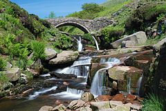
 River Dane and packhorse bridge at Three Shire Heads | |
Location within Staffordshire | |
| OS grid reference | SK009685 |
| District | |
| Shire county | |
| Region | |
| Country | England |
| Sovereign state | United Kingdom |
Three Shire Heads (also known as Three Shires Head) is the point on Axe Edge Moor where Cheshire, Derbyshire and Staffordshire meet, at UK grid reference SK009685, or 53°12′47″N 1°59′13″W / 53.213°N 1.987°W.
It is on the River Dane, which marks the Cheshire border in this area. On the east of the river, the border between Staffordshire and Derbyshire runs north-east for about a mile to Cheeks Hill, on the higher regions of Axe Edge Moor. From Cheeks Hill the border runs south then east to the head of the River Dove.[1]
The main landmark is a packhorse bridge. The bridge is Grade II-listed, and was probably constructed in the late 18th century.[2]
- ^ Ordnance Survey Landranger 1:50000 map, Sheet 119 (Buxton, Matlock and Dove Dale)
- ^ Historic England. "Three Shire Heads bridge (1145883)". National Heritage List for England. Retrieved 24 August 2013.

