Back ترينداد ومارتين فاز Arabic Trindadi-e-Martin-Vas Azerbaijani Трындады-э-Марцін-Вас Byelorussian Триндади и Мартим Вас Bulgarian Trindade e Martim Vaz Breton Trindade i Martim Vaz Catalan Trindade a Martim Vaz Czech Trindade og Martim Vaz Danish Trindade und Martim Vaz German Τριντάντε και Μάρτιμ Βαζ Greek
It has been suggested that this article be split into articles titled Trindade (island), Martim Vaz and Trindade and Martim Vaz (geography). (discuss) (December 2023) |
 Rocky cliffs of Trindade Island | |
 | |
| Geography | |
|---|---|
| Location | Atlantic Ocean |
| Coordinates | 20°31′30″S 29°19′30″W / 20.52500°S 29.32500°W |
| Archipelago | Arquipélago de Trindade e Martim Vaz |
| Total islands | 5 |
| Major islands | Trindade; Martim Vaz |
| Area | 10.4 km2 (4.0 sq mi) |
| Highest elevation | 620 m (2030 ft) |
| Highest point | Pico do Desejado[1] |
| Administration | |
| Region | Southeast |
| State | Espírito Santo |
| Administration | 1st Naval District of the Brazilian Navy |
| Demographics | |
| Population | Research station for up to 8 persons[2] |
| Additional information | |
| Time zone |
|
| Official website | Brazilian Navy First Naval District |
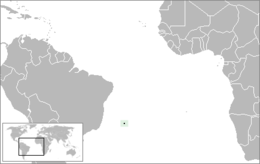
Trindade and Martim Vaz[3] (Portuguese: Trindade e Martim Vaz, pronounced [tɾĩˈdadʒi i mɐʁˈtʃĩ ˈvas]) is an archipelago located in the South Atlantic Ocean about 1,100 kilometres (680 miles) east off the coast of the Brazilian state of Espírito Santo, of which it forms a part. The archipelago has a total area of 10.4 square kilometres (4.0 square miles) and a navy-supported research station of up to 8 persons.[2][4] The archipelago consists of five islands and several rocks and stacks; Trindade is the largest island, with an area of 10.1 square kilometres (3.9 square miles); about 49 kilometres (30 miles) east of it are the tiny Martim Vaz islets, with a total area of 0.3 square kilometres (30.0 hectares).
The islands are of volcanic origin and have rugged terrain the date of last eruption in the island is unknown but occurred on the SE tip of the island at volcao de paredao.[5]They are largely barren, except for the southern part of Trindade. They were discovered in 1502 by Portuguese explorer Estêvão da Gama and stayed Portuguese until they became part of Brazil at its independence in 1822. From 1895 to 1896, Trindade was occupied by the United Kingdom until an agreement with Brazil was reached. During the period of British occupation, Trindade was known as South Trinidad.
The islands are situated some 2,100 kilometres (1,300 miles) southwest of Ascension Island and 2,550 kilometres (1,580 miles) west of Saint Helena, and the distance to the west coast of Africa is 4,270 kilometres (2,650 miles).
Due the introduction of invasive species such as sheep, etc. the island's biodiversity has heavily deteriorated since the second half of the 20th century, with many indigenous species becoming endangered.[6]
- ^ Ilha da Trindade - Infográficos e mapas Folha de S.Paulo. Retrieved on 6 June 2009.
- ^ a b "PROGRAMA DE PESQUISAS CIENTÍFICAS NA ILHA DA TRINDADE". CIRM (in Portuguese). 2017-06-30. Retrieved 2021-12-29.
- ^ National Geospatial-Intelligence Agency Web: http://geonames.nga.mil/namesgaz/
- ^ "Conheça o Arquipélago de Trindade e Martim Vaz". Mar Sem Fim. 8 February 2019. Retrieved 28 March 2021.
- ^ "Trindade volcano".
- ^ "Islands off the coast of eastern Brazil - Ecoregions - WWF". World Wildlife Fund. Retrieved 2021-12-29.