Back منطقة أودايبور Arabic اودايبور ARZ उदयपुर जिला Bihari উদয়পুর জেলা, রাজস্থান Bengali/Bangla Udaipur (distrito) CEB Udaipur (distrikt) Danish Udaipur (Distrikt) German Distrito de Udaipur Spanish Udaipur barrutia Basque بخش اودایپور Persian
Udaipur district | |
|---|---|
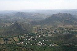
Clockwise from top-left: View of Udaipur from City Palace, Jaisamand Lake, Ghats at Udaipur, Aravalli Hills, Jagdhish Temple | |
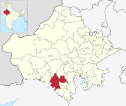
 Location of Udaipur district in Rajasthan | |
| Coordinates (Udaipur): 24°23′N 73°37′E / 24.383°N 73.617°E | |
| Country | |
| State | Rajasthan |
| Division | Udaipur |
| Headquarters | Udaipur |
| Tehsils | 1.Badgaon 2.Bhindar 3.Girwa 4.Gogunda 5.Jhadol 6.Kanor 7.Kherwara 8.Kotra 9.Lasadiya 10.Mavli 11.Rishabhdeo 12.Salumbar 13.Semari 14.Sarada 15.Vallabhnagar |
| Government | |
| • Lok Sabha constituencies | District spread over 2 constituencies - Udaipur and Chittorgarh |
| • Vidhan Sabha constituencies | 9 |
| Area | |
• Total | 11,724 km2 (4,527 sq mi) |
| Population (2011)[1] | |
• Total | 3,068,420 |
| • Density | 260/km2 (680/sq mi) |
| • Urban | 19.83% |
| Demographics | |
| • Literacy | 61.82%[2] |
| • Sex ratio | 958 |
| Languages | |
| • Official | Hindi |
| • Regional | Mewari |
| Time zone | UTC+05:30 (IST) |
| Major highways | National Highways 8, 76 |
| Average annual precipitation | 554 mm |
| Website | udaipur |
Udaipur district is one of the 50 districts of Rajasthan state in western India.[3] The historic city of Udaipur is the administrative headquarters of the district.[2] The district is part of the Mewar region of Rajasthan.[4]
- ^ Cite error: The named reference
Census_2011_Bwas invoked but never defined (see the help page). - ^ a b District Census Handbook Udaipur, Village and Town Directory Part XII-A. Series-09, Part XII-A. Directorate of Census Operations Rajasthan. 2011.
- ^ "Statistical Data of Rajasthan State Pertaining to Census-2011". www.rajcensus.gov.in. Retrieved 7 September 2018.
- ^ Agarwal, B.D. (1979). Rajasthan District Gazeteers Udaipur. Jaipur: Directorate of District Gazeteers.


