| Urrbrae Adelaide, South Australia | |||||||||||||||
|---|---|---|---|---|---|---|---|---|---|---|---|---|---|---|---|
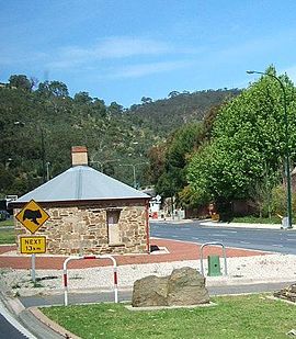
 Old Toll House. Urrbrae is to the right. | |||||||||||||||
| Coordinates | 34°58′11″S 138°38′18″E / 34.969636°S 138.638405°E[1] | ||||||||||||||
| Population | 1,070 (SAL 2021)[2] | ||||||||||||||
| Postcode(s) | 5064 | ||||||||||||||
| Time zone | ACST (UTC+9:30) | ||||||||||||||
| • Summer (DST) | ACST (UTC+10:30) | ||||||||||||||
| Location | 5.6 km (3 mi) SE of Adelaide CBD[3] | ||||||||||||||
| LGA(s) | City of Mitcham | ||||||||||||||
| Region | Southern Adelaide[1] | ||||||||||||||
| County | Adelaide[1] | ||||||||||||||
| State electorate(s) | Waite | ||||||||||||||
| Federal division(s) | Boothby | ||||||||||||||
| |||||||||||||||
| Footnotes | Adjoining suburbs[1] | ||||||||||||||
Urrbrae is a suburb of Adelaide, South Australia. It is located in the City of Mitcham.
Located at the foot of the Adelaide Hills, it is bordered on the east by the South Eastern Freeway, and the Old Toll House, which marked the traditional entrance to the city of Adelaide in the 19th century.
- ^ a b c d "Search results for 'Urrbrae, SUB' with the following datasets selected – 'Suburbs and localities', 'Counties', 'Local Government Areas', 'SA Government Regions' and 'Gazetteer'". Location SA Map Viewer. Government of South Australia. Retrieved 27 October 2022.
- ^ Australian Bureau of Statistics (28 June 2022). "Urrbrae (suburb and locality)". Australian Census 2021 QuickStats. Retrieved 28 June 2022.
- ^ "Urrbrae, South Australia (Adelaide)". Postcodes-Australia. Postcodes-Australia.com. Retrieved 15 April 2011.
- ^ Australian Bureau of Statistics (25 October 2007). "Urrbrae (State Suburb)". 2006 Census QuickStats. Retrieved 14 April 2011.
- ^ Australian Bureau of Statistics (27 June 2017). "Urrbrae (State Suburb)". 2016 Census QuickStats. Retrieved 5 April 2020.

