Back Valletta Afrikaans Valletta ALS ቫሌታ Amharic Valletta AN Falletta ANG فاليتا Arabic ڤاليطا ARY فاليتا ARZ La Valeta AST Valletta AVK
Valletta
Il-Belt Valletta (Maltese) | |
|---|---|
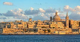
From top: Skyline, Saluting Battery, Lower Barrakka Gardens, St. John's Co-Cathedral and the city walls | |
| Nickname: Il-Belt | |
| Motto: City Built By Gentlemen For Gentlemen | |
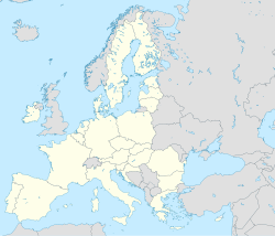
Map of the Maltese Archipelago with Valletta | |
| Coordinates: 35°53′54″N 14°30′45″E / 35.89833°N 14.51250°E[1] | |
| Country | Malta |
| Region | Port Region |
| District | Southern Harbour District |
| Capital city | 18 March 1571 |
| Founded by | Jean de Parisot Valette |
| Borders | Floriana |
| Government | |
| • Mayor | Olaf McKay (PL) |
| Area | |
• Capital city and local council | 0.61 km2 (0.24 sq mi) |
| • Urban | 256 km2 (99 sq mi) |
| Elevation | 56 m (184 ft) |
| Population (Jan. 2019) | |
• Capital city and local council | 5,157 |
| • Density | 8,500/km2 (22,000/sq mi) |
| • Urban | 480,134[2] |
| Demonym(s) | Belti (m), Beltija (f), Beltin (pl) |
| Time zone | UTC+1 (CET) |
| • Summer (DST) | UTC+2 (CEST) |
| Postal code | VLT |
| Dialing code | 356 |
| ISO 3166 code | MT-60 |
| Patron saints | St. Dominic Our Lady of Mount Carmel St. Paul St. Augustine |
| Day of festa | 3 August 10 February |
| Website | Official website |
| Official name | City of Valletta |
| Criteria | Cultural: i, vi |
| Reference | 131 |
| Inscription | 1980 (4th Session) |
| Area | 55.5 ha |
Valletta (/vəˈlɛtə/ ⓘ və-LET-ə; Maltese: il-Belt Valletta, pronounced [vɐlˈlɛttɐ]) is the capital city of Malta and one of its 68 council areas. Located between the Grand Harbour to the east and Marsamxett Harbour to the west, its population as of 2021 was 5,157.[3] As Malta’s capital city, it is a commercial centre for shopping, bars, dining, and café life. It is also the southernmost capital of Europe,[4][note 1] and at just 0.61 square kilometres (0.24 sq mi), it is the European Union's smallest capital city.[5][6]
Valletta's 16th-century buildings were constructed by the Knights Hospitaller. The city was named after the Frenchman Jean Parisot de Valette, who succeeded in defending the island against an Ottoman invasion during the Great Siege of Malta. The city is Baroque in character, with elements of Mannerist, Neo-Classical and Modern architecture, though the Second World War left major scars on the city, particularly the destruction of the Royal Opera House. The city was officially recognised as a World Heritage Site by UNESCO in 1980.[7] The city has 320 monuments, all within an area of 0.55 square kilometres (0.21 sq mi), making it one of the most concentrated historic areas in the world.[7][8] Sometimes called an "open-air museum",[9] Valletta was chosen as the European Capital of Culture in 2018. Valletta was also listed as the sunniest city in Europe in 2016.[10][11]
The city is noted for its fortifications, consisting of bastions, curtains and cavaliers, along with the beauty of its Baroque palaces, gardens and churches.
- ^ Badger, George Percy (1869). Historical Guide to Malta and Gozo. Calleja. pp. 152.
Castellania building.
- ^ "Population on 1 January by age groups and sex – functional urban areas". Eurostat. 2020. Retrieved 5 March 2022.
- ^ "Estimated Population by Locality 31st March, 2014". Government of Malta. 16 May 2014. Archived from the original on 21 June 2015. Retrieved 21 June 2015.
- ^ Valletta, Malta – Intercultural City – Council of Europe
- ^ "The 10 Smallest Countries in Europe". World Atlas. 31 May 2018.
- ^ "History of Valletta – Story About Valletta – Interesting Facts". www.visitmalta.com. Retrieved 29 February 2020.
- ^ a b "City of Valletta". UNESCO World Heritage List. Retrieved 18 July 2015.
- ^ "Valletta travel". Lonely Planet. Retrieved 11 January 2023.
- ^ Valletta (Malta) – The Complete Overview of Malta's Capital City – maltauncovered.com
- ^ Valletta is crowned the sunniest city in Europe Archived 5 March 2022 at the Wayback Machine – bay.com.mt, 2016
- ^ Sunniest Cities in Europe – currentresults.com, 2016
Cite error: There are <ref group=note> tags on this page, but the references will not show without a {{reflist|group=note}} template (see the help page).


