Back ویورلی، نیو ساوت ولز Persian Waverley (Australie) French וייברלי HE Waverley, New South Wales Malay Waverley, New South Wales Romanian ویورلی، نیوساؤتھ ویلز Urdu
| Waverley Sydney, New South Wales | |||||||||||||||
|---|---|---|---|---|---|---|---|---|---|---|---|---|---|---|---|
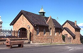
 Waverley Cemetery office building | |||||||||||||||
 | |||||||||||||||
| Population | 4,216 (2021 census)[1] | ||||||||||||||
| Postcode(s) | 2024 | ||||||||||||||
| Elevation | 94 m (308 ft) | ||||||||||||||
| Location | 7 km (4 mi) east of Sydney CBD | ||||||||||||||
| LGA(s) | Waverley Municipal Council | ||||||||||||||
| State electorate(s) | Coogee | ||||||||||||||
| Federal division(s) | Wentworth | ||||||||||||||
| |||||||||||||||
Waverley is a suburb in the Eastern suburbs of Sydney, in the state of New South Wales, Australia. Waverley is located seven kilometres east of the Sydney central business district, in the local government area of Waverley Council.[2]
Waverley Council takes its name from the suburb but its administrative centre is located in the adjacent suburb of Bondi Junction, which is also a major commercial centre. Waverley is the highest point of altitude in Sydney's Eastern Suburbs.
- ^ Australian Bureau of Statistics (28 June 2022). "Waverley (State Suburb)". 2021 Census QuickStats. Retrieved 19 October 2024.
- ^ Gregory's Sydney Street Directory, Gregory's Publishing Company, 2007