Back Western Water Catchment German Kawasan Tadahan Air Barat (Singapura) ID Western Water Catchment Dutch Western Water Catchment NB مغربی واٹر کیچمینٹ Urdu 西部集水區 Chinese Se-pō͘ Chi̍p-chúi-khu ZH-MIN-NAN
Western Water Catchment | |
|---|---|
| Other transcription(s) | |
| • Chinese | 西部集水区 (Simplified) 西部集水區 (Traditional) Xībù Jíshuǐqū (Pinyin) Se-pō͘ Chi̍p-chúi-khu (Hokkien POJ) |
| • Malay | Kawasan Tadahan Air Barat (Rumi) کاوسن تادهن اءير بارت (Jawi) |
| • Tamil | மேற்கத்திய நீர் நீர்ப்பிடிப்பு Mēṟkattiya nīr nīrppiṭippu (Transliteration) |
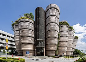
From top to bottom: An overview of Pasir Laba Camp, soldiers at the Murai Urban Training Facility, The Hive building at Nanyang Technological University | |
 Location of Western Water Catchment in Singapore | |
| Coordinates: 1°23′13″N 103°41′31″E / 1.387°N 103.692°E | |
| Country | |
| Region | West Region
|
| CDC | |
| Town councils |
|
| Constituencies | |
| Government | |
| • Mayor | South West CDC
|
| • Members of Parliament | Chua Chu Kang GRC
West Coast GRC
|
| Area | |
• Total | 69.5 km2 (26.8 sq mi) |
| • Rank | 1st |
| Population | |
• Total | 600 |
| • Rank | 41th |
| • Density | 8.6/km2 (22/sq mi) |
| • Rank | 42nd |
| Postal district | 24 |
The Western Water Catchment is a planning area located in the West Region of Singapore. The planning area borders Tuas and Pioneer to its south, Sungei Kadut, Choa Chu Kang and Tengah to its east, Jurong West to its southeast, Lim Chu Kang to its north and the Straits of Johor to its west. It is the largest planning area by land area, covering nearly a tenth of Singapore Island. It is also one of the two main water catchments in Singapore, the other being Central Water Catchment.
The area currently houses four reservoirs, Tengeh Reservoir, Poyan Reservoir, Murai Reservoir and Sarimbun Reservoir. Part of the Western Water Catchment is also a live-firing area in which it is used by the Singapore Armed Forces for training purposes.
The SAFTI Live Firing Area commenced operations in 1968 and was revamped in 2008, the eastern part began operations in 2002 and has been extended to Lim Chu Kang Tracks 11 and 13.
- ^ a b "Singapore: Subdivision (Planning Areas and Subzones) - Population Statistics, Charts and Map". www.citypopulation.de.
- ^ "Statistics Singapore - Geographic Distribution - Latest Data". Retrieved 10 January 2025.


