Back Wixoe CEB Wixoe French Wixoe LLD Wixoe Dutch Wixoe Polish Wixoe Swedish Wixoe Turkish Wixoe ZH-MIN-NAN
| Wixoe | |
|---|---|
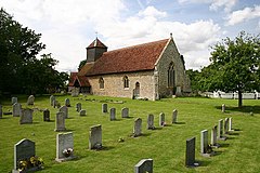
 St Leonard's Church, Wixoe | |
Location within Suffolk | |
| Population | 140 (2005)[1] 145 (2011)[2] |
| District | |
| Shire county | |
| Region | |
| Country | England |
| Sovereign state | United Kingdom |
| Post town | Sudbury |
| Postcode district | CO10 |
| Police | Suffolk |
| Fire | Suffolk |
| Ambulance | East of England |
| UK Parliament | |
Wixoe is a village and civil parish in the West Suffolk district of Suffolk in eastern England. Located on the northern bank of the River Stour, two miles south-east of Haverhill, in 2005 its population was 140.[1] It consists largely of Victorian cottages along a narrow lane. There is a church of 12th-century origin, St Leonard's, much restored in the 1880s.[3] It was recorded in the Domesday Book,[4] at 600 acres one of the smallest parishes in the hundred of Risbridge. There are some 13 listed buildings, including a 19th-century bridge and a water mill.[5]
The Great Eastern Railway ran through the village, part of the Stour Valley line from 1865 until its closure in March 1967 under the Beeching 'axe'. The nearest stations were Sturmer to the west and Stoke-by-Clare to the east.[6] The track bed and embankments remain clearly visible.
- ^ a b Estimates of Total Population of Areas in Suffolk Archived 19 December 2008 at the Wayback Machine Suffolk County Council: this page is no longer available - update from Census 2011 when available
- ^ "Civil Parish population 2011". Neighbourhood Statistics. Office for National Statistics. Retrieved 30 August 2016.
- ^ Suffolk Churches website: Simon Knott
- ^ http://domesdaymap.co.uk/place/TL7142/wixoe/ Online copy
- ^ British Listed Buildings website
- ^ Any Wallis, Stour Valley Railway Part 2 Through Time Clare to Shelford and Audeley End, Amberley Publishing 2011 ISBN 978 1-4456-0473-2, pp 13-24
