Back متنزه صهيون الوطني Arabic متنزه زايون الوطنى ARZ Zayon Milli Parkı Azerbaijani Taman Nasional Zion BAN Зайон (национален парк) Bulgarian Parc Nacional Zion Catalan Zion National Park CEB Národní park Zion Czech Zion National Park Danish Zion-Nationalpark German
| Zion National Park | |
|---|---|
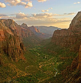
 Zion Canyon from Angels Landing at sunset | |
| Location | Washington, Kane, and Iron counties, Utah, United States |
| Nearest city | Springdale (south), Orderville (east) and Cedar City near Kolob Canyons entrance |
| Coordinates | 37°18′N 113°00′W / 37.300°N 113.000°W |
| Area | 146,597 acres (229.058 sq mi; 59,326 ha; 593.26 km2)[1] |
| Established | November 19, 1919[2] |
| Visitors | 4,623,238 (in 2023)[3] |
| Governing body | National Park Service |
| Website | Zion National Park |
Zion National Park is a national park of the United States located in southwestern Utah near the town of Springdale. Located at the junction of the Colorado Plateau, Great Basin, and Mojave Desert regions, the park has a unique geography and a variety of life zones that allow for unusual plant and animal diversity. Numerous plant species as well as 289 species of birds, 75 mammals (including 19 species of bat), and 32 reptiles inhabit the park's four life zones: desert, riparian, woodland, and coniferous forest. Zion National Park includes mountains, canyons, buttes, mesas, monoliths, rivers, slot canyons, and natural arches. The lowest point in the park is 3,666 ft (1,117 m) at Coalpits Wash and the highest peak is 8,726 ft (2,660 m) at Horse Ranch Mountain. A prominent feature of the 229-square-mile (590 km2) park is Zion Canyon, which is 15 miles (24 km) long and up to 2,640 ft (800 m) deep. The canyon walls are reddish and tan-colored Navajo Sandstone eroded by the North Fork of the Virgin River. The park attracted 5 million visitors in 2023.[4]
Human habitation of the area started about 8,000 years ago with small family groups of Native Americans, one of which was the semi-nomadic Basketmaker Ancestral Puebloans (who used to be called Anasazi by early non-indigenous archeologists[5]) (c. 300 CE). Subsequently, what has been called the Virgin Anasazi culture (c. 500) and the Parowan Fremont group developed as the Basketmakers settled in permanent communities.[6] Both groups moved away by 1300 and were replaced by the Parrusits and several other Southern Paiute subtribes. Mormons came into the area in 1858 and settled there in the early 1860s.
- ^ "Listing of acreage – December 31, 2012" (XLSX). Land Resource Division, National Park Service. Retrieved March 31, 2013. (National Park Service Acreage Reports)
- ^ "Zion-Mt. Carmel Highway and Tunnel". National Park Service. Archived from the original on October 12, 2013. Retrieved March 31, 2013.
- ^ "Annual Park Ranking Report for Recreation Visits in: 2022". nps.gov. National Park Service. Retrieved July 23, 2023.
- ^ "Top 10 most visited national parks". Travel. March 27, 2024. Retrieved March 27, 2024.
- ^ Cordell, Linda (1994). Ancient Pueblo Peoples. St. Remy Press and Smithsonian Institution. pp. 18–19. ISBN 0-89599-038-5.
- ^ Tufts 1998, p. 45

